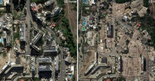
The combination of two powerful, very shallow earthquakes just 39 seconds apart explains much of the devastation left by Wednesday's earthquake in north-central Venezuela, where the latest official toll exceeds 1,450 dead and 3,150 injured. The satellite images that have gradually emerged confirm a trail of collapsed buildings along the coast, the most densely populated and hardest-hit area.
The first tremor, of magnitude 7.2, had its epicenter in Yaracuy state, west of La Guaira and Caracas. The second, 39 seconds later and of magnitude 7.5, released almost three times more energy than the first, according to the US Geological Survey. Both occurred at a shallow depth —the main one at about ten kilometers— a decisive factor in the scale of the surface damage. “Not only was the energy high, but they were also very shallow, especially the second, which is devastating,” Miguel Ángel Rodríguez Pascua, of Spain's Geological and Mining Institute, told EL PAÍS. Another element worsened the consequences: because the two quakes occurred within less than a minute, many people did not have time to evacuate their buildings between one and the other.
The destruction followed the line of the San Sebastián fault, running parallel to the coast, at the boundary between the Caribbean and South American plates. Images from companies such as Vantor and Planet Labs show collapsed apartment towers and resorts in the coastal towns of Catia La Mar, Macuto and Caraballeda, the latter one of the worst affected. The collapse of a twelve-story building in Caraballeda has become one of the symbols of the tragedy. A preliminary analysis by Oregon State University, based on European satellite data, estimated that close to 58,900 buildings were damaged or destroyed.
The scale of the disaster is also reflected in economic estimates: the United Nations Development Programme calculated damage to housing and assets in a range of between $4.7 billion and $8.7 billion, around 6% of Venezuela's gross domestic product. The US Geological Survey, through its rapid-assessment system, identified both thousands and tens of thousands of deaths as probable scenarios; this is a statistical model based on intensity and exposed population, not a count. The number of missing is the subject of conflicting accounts, with international bodies mentioning tens of thousands and a government that maintains they number in the hundreds.
Wednesday's quake is the most powerful recorded in the seismic region of northern Venezuela in more than a century. To find one of similar magnitude, one must go back to 1900, when a magnitude 7.7 earthquake struck the central coast, near Caracas. In 2018, a magnitude 7.3 tremor —almost as strong— originated at a depth of about 150 kilometers and caused just five deaths, a difference that illustrates the decisive weight of depth in an earthquake's lethality.
Top Comments
Disclaimer & comment rulesNo comments for this story
Please log in or register (it’s free!) to comment. Login with Facebook
Facts Only
* Two earthquakes occurred 39 seconds apart in north-central Venezuela.
* The first tremor had a magnitude of 7.2 and its epicenter was in Yaracuy state, west of La Guaira and Caracas.
* The second tremor had a magnitude of 7.5 and released almost three times more energy than the first.
* Both quakes occurred at shallow depths, with the main one at about ten kilometers.
* Damage followed the line of the San Sebastián fault.
* Collapsed apartment towers and resorts were visible in coastal towns like Catia La Mar, Macuto, and Caraballeda.
* A twelve-story building collapse in Caraballeda is noted as a symbol of the tragedy.
* An estimated 58,900 buildings were damaged or destroyed based on preliminary analysis.
* Damage to housing and assets was calculated between $4.7 billion and $8.7 billion by the UNDP.
* Official toll reported exceeds 1,450 dead and 3,150 injured.
* The quake was the most powerful recorded in the seismic region of northern Venezuela in over a century.
Executive Summary
Full Take
Sentinel — Human
The text functions as high-quality, fact-based reporting. While the structure is highly logical, the specific attribution of data strongly suggests human journalistic compilation rather than pure machine generation.